This document presents the CarbonGeoScales project: A framework for standardizing available GHGs emissions open data at multiple geographical scales. A complementary technical report presenting a comprehensive cartography of GHGs emissions open data with our first explorations and modeling is available in this link.
Key words:
Open Data,Geospatial scales,Climate Change,GHG emissions,Standardization,Open SourceAuthor and project manager: Saif Shabou
Github repository: CarbonData
Date: 11/03/2021
Context
Greenhouse gas (GHGs) emissions from human activities are considered as the most significant driver of observed climate change since the mid-20th century. In order to better mitigate climate change impacts, policy makers, scientists, carbon and environment consultancy specialists, data journalists and citizens need easy and free access to relevant and accurate data on GHGs emissions at various spatial scales.
In accordance with the Paris Agreement, countries are required to submit transparent, comparable and complete reporting of GHGs inventories based on the methodologies developed by the IPCC. In addition to these Top-Down approaches, Bottom-Up methods are being used for completing emissions estimates based on satellite imagery and carbon monitoring stations at different spatial scales. At subnational scales, important efforts and specific protocols are deployed providing methodologies for measuring city-scale emissions since they represent a large percent of energy-related GHGs emissions.
Pain points
While several open data platforms and portals are engaged in publishing relevant collected GHGs emissions data (Carbon Disclosure Project, World Resources Institute, EDGAR database,UNFCCC…), the use of this data remain often complex and time consuming due to their different formats, schemas, standards, scales, protocols, units,spatio-temporal coverage, data definitions…
Identification and mapping of the appropriate sources as well as various data processing treatments (cleaning, recoding, normalization, cross-referencing, aggregating…) are often necessary before being able to use the available data and combine it with other indicators.
Our solution: CarbonGeoScales
Goals
The main goal of CarbonGeoScales consists of providing a centralized access point to updated, accurate, harmonized, and aggregated GHGs emissions data at multiple geographical scales.
As an open source and collaborative project, different data processing treatments are accessible in order to provide users with transformation processes implemented on raw collected data. The resulting compiled database is accessible by download and through specific API for querying and integrating aggregated data into potential applications. Resulting harmonized GHGs emissions data are completed with consistent documentation, articles and dashboards for exploring its content.
By facilitating access to GHGs emissions open data, CarbonGeoScales is participating to help policy makers to build more effective emissions reduction strategies at different territorial scales and to track their progress more accurately. Standardidzed data facilitates data use for carbon analytics specitalists (scientists, NGOs and carbon consultancy offices) in order to combine it with external datasets.
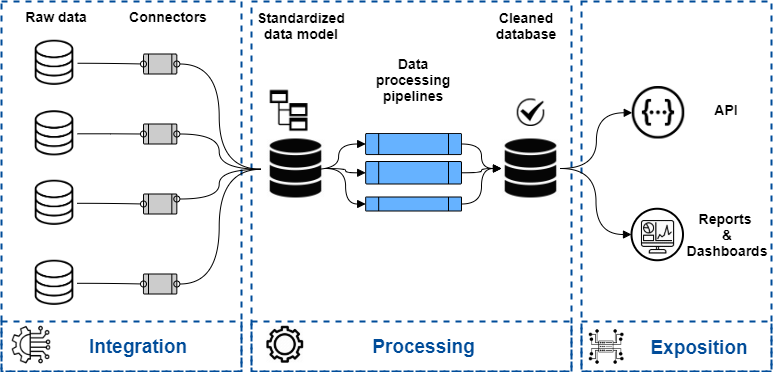
Technical components
CarbonGeoScales is based on a complete data workflow in order to deliver relevant and harmonized GHGs emissions datasets:
- Data catalog for referencing identified GHGs emissions data and associated metadatas.
- A standardized data model for storing different attributes of GHGs emissions data (values, dates, units, sectors, scopes, geographical entity informations…)
- A set of connectors for integrating selected raw data into the defined data model based on specific mapping rules.
- Harmonized databases for storing collected and transformed GHGs emissions data.
- Data processing pipelines for implementing the necessary transformations (recoding, enriching, cleaning, aggregating…).
- A Rest API for querying the compiled database.
- A set of reporting, articles and dashboards for providing insights on GHGs emissions at various scales.
Used datasets
We identified various GHGs emissions datasets providing information on emissions estimates based on multiple protocols and standards. The table below lists main datasets by specifying data providers, data sources, geographical scale and spatial resolutions. A more detailed analysis of data contents is provided in this report.
| Data provider | Description | Geoscale | Data sources | Access |
|---|---|---|---|---|
| The World Resources Institute (WRI) | The World Resources Institute compiles various sources of GHG emissions and provide access to this data through a specific tool: CLIMAT WATCH. Provided GHG emissions data is based on various data sources: CAIT database, UNFCCC, PIK. | World scale Country scale |
CAIT UNFCCC PIK |
Get data |
| The United Nations Framework Convention on Climate Change (UNFCCC) | The UNFCCC compiles and shares national annual greenhouse gases inventories submitted in accordance with with the reporting requirements adopted under the Climate Change Convention | World scale Country scale |
UNFCCC |
Get data |
| Potsdam Institute for Climate Impact Research (PIK) | The Postdam Institute provides the PRIMAP-hist dataset, which combines several published datasets to create a comprehensive set of greenhouse gas emission pathways for every country and Kyoto gas covering the years 1850 to 2017, and all UNFCCC (United Nations Framework Convention on Climate Change) member states, as well as most non-UNFCCC territories. | World scale Country scale |
UNFCCC EDGAR |
Get data |
| The Joint Research Center of Euorpean Commission | The Joint Research center produces the Emission Database for Global Atmospheric Research (EDGAR). EDGAR provides independent estimates of the global anthropogenic emissions and emission trends, based on publicly available statistics, for the atmospheric modeling community as well as for policy makers. This scientific independent emission inventory is characterized by a coherent world historical trend from 1970 to year x-3, including emissions of all greenhouse gases, air pollutants and aerosols. Data are presented for all countries, with emissions provided per main source category, and spatially allocated on a 0.1x0.1 grid over the globe | World scale Country scale Grid scale |
EDGAR |
Get data |
| The Organization for Economic Co-Operation and Development (OECD) | The OECD publishes datasets presenting trends in man-made emissions of major greenhouse gases and emissions by gas. | OECD scale Country scale |
UNFCCC |
Get data |
| European Environmental Agency (EEA) | The EEA compiles and provides data on greenhouse gas emissions and removals, sent by countries to UNFCCC and the EU Greenhouse Gas Monitoring Mechanism (EU Member States). | Europe scale Country scale |
UNFCCC |
Get data |
| Eurostat | Eurostat (European Statistical Office) is a Directorate-General of the European Commission. It provides statistical information to the institutions of the European Union (EU) such as a comprehensive set of climate change-related data including GHG emissions statistics. Eurostat maintains a data portal for exploring emissions data. | Europe scale Country scale |
EEA UNFCCC |
Get data |
| Our World In Data | Our World In Data compile, maintain and shares CO2 and GHG emissions data. It is updated regularly and includes data on CO2 emissions (annual, per capita, cumulative and consumption-based), other greenhouse gases, energy mix, and other relevant metrics. | World scale Country scale |
GCP CAIT |
Get data |
| Global Carbon Project (GCP) | GCP is a global research project that seeks to quantify global greenhouse gas emissions and their causes. It provides data on carbon fluxes resulting from human activities and natural processes and a platform to explore and visualize the most up-to-date data (Gloabl carbon Atlas) | World scaleCountry scaleCity scale |
GCP |
Get data |
| Carbon Disclosure Project (CDP) | The CDP is an international non-profit organisation that helps companies and cities disclose their environmental impact and GHG emissions. CDP provides an open data protal for exploring companies and city-wide collected data. | City scale |
CDP |
Get data |
Users
By providing harmonized, relevant and ready-to-use multi-scale GHGs emissions open data, CarbonGeoScales fulfill the needs of various profiles of GHGs data users and carbon issues specialists:
- Data journalists specialized in climate change issues who need easy access to standardized open data with visualizations charts and comprehensive documentation to support their articles and reports.
- Carbon consultancy specialists who need GHGs emissions estimates for conducting carbon foortprint analysis to their clients (companies, facility level, municipalities…). CarbonGeoScales provide them with API access to processed data at different scales. API use might be monetized according of request number or specific attributes and features to integrate (data update frequency ,support ,specific use cases…).
- Policy makers for better mitigating climate actions and tracking their progress in reducing emissions at various geographical and administrative scales by comparative analysis which need standardized data.
- Scientists working in downscaling GHGs emissions estimates who need high-resolution bottom-up GHGs emissions estimates for parametrizing carbon monitoring simulation in combination with atmospheric concentration measurements and image stallites retrieval.
- NGOs specialists in climate issues and carbon analytics by providing them with standardized data and visualizations to integrate in their reoprts, websites and applications.
Roadmap
Beta version
The figure below presents prelimenrary roadmap for delivering the Beta version of CarbonGeoScales as a part of Data For Good acceleration 3 months program starting from April 1st 2021. This first prototype adresses only the standardization of Bottmo-Up GHGs emission data at multiple scales in Fench terriotory.

Future releases
Different improvements and new features have been identified for next releases of CarbonGeoScales:
- GHGs emissions data: Including Top-down estimates based on satellite images and ground based carbon monitoring stations in order to leverage uncertainties due to reporting bias.
- Data visualization: Developing geo-visualization dashboards for exploring CarbonGeoScales database
- Geographical coverage: Extending the spatial coverage of compiled data and implementing Beta version prototype to other territories and geographical scales.
- Communication: Developing a dedicated web site for hosting and sharing documentation and articles based on CarbonGeoScales database and API.
- Performance: Improving database performance and data models by providing appropriate data storage and pipleines infrastructure.
Project management
-
Code source: The actual code source of CarbonGeoScales project is hosted in this Github repository. Github Project Board is used for managing the collaboration in the developement of different fetaures and issues.
-
Documentation: The actual documentation is hosted in Github wiki pages. More appropriate documentation will be available soon in a specific documentation website.
-
Contribution modalities: Contribution modalities are incremently specified in the readme page. A slack canal will be shared soon for facilitating interaction between contributors.
Partnerships
CarbonGeoScales has been selected by Data For Good in order to deliver first prototype based on French GHGs emissions data. More partnerhips need to be set up with organisms specialized in open data, climate change issues and city-scale carbon monitoring in order to improve the consistency of delivered standardized data:
- Open Data: Our World in Data, World resources Institute, The Open Source geospatial Foundation (OSCGeo), Open Data Institute, Open Knowldge Foundation, Open data for development, Global Partnership for Sustainable Development Data…
- Carbon Data: Open Carbon Watch, Integrated Carbon Observation System, OS-climat, Carbon Disclosure Project (CDP)…
- City scale data: C40 cities, Global Govenant of Mayors for Climate & Energy, Local Governments for Sustainability (ICLEI), Carbon Neutral Cities Alliance…
![]()